Advanced Borehole Imaging
See the geology around your wellbore in unprecedented detail — fractures, bedding, stress, and structure.
What You Get:
What Is Advanced Borehole Imaging?
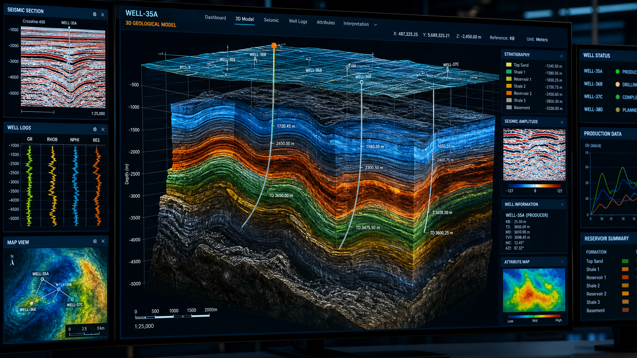
Advanced borehole imaging creates a detailed, high-resolution map of the rock formations surrounding your wellbore. Instead of measuring averaged formation properties (like standard logging tools do), imaging sensors scan the entire wellbore wall and produce a continuous 360-degree picture of the geology at millimeter-scale resolution.
This reveals features that standard logs simply cannot see: natural fractures, thin bedding layers, stress-induced breakouts, vugs, faults, and fine geological structures that control fluid flow and wellbore stability.
Why Standard Logs Miss Critical Details
Conventional wireline logs measure averaged properties over relatively large volumes of rock. That is valuable for bulk formation evaluation, but it cannot resolve the fine-scale features that often control well performance. Natural fractures, micro-faults, thin laminations, and in-situ stress indicators are frequently the most important factors — and they are invisible to standard tools.
Without imaging data, completion strategy, stimulation design, and production optimization decisions are made without full knowledge of the geological complexity around the wellbore.
Imaging Technologies
- Acoustic Imaging — uses focused ultrasound pulses to map the wellbore surface. Works in any fluid type including oil-based mud. Provides both amplitude and transit time images. Ideal for cased-hole cement evaluation and open-hole imaging in non-water-based systems.
- Resistivity Imaging — multiple micro-resistivity electrodes pressed against the borehole wall measure tiny electrical variations. Provides the highest resolution images available (sub-millimeter in some tools) and excels at identifying fine fractures, thin beds, and textural features.
What Imaging Reveals
- Natural fractures — orientation, aperture, and density of fracture systems that control fluid flow.
- Structural dip and bedding — precise formation dip angle and azimuth for geological mapping.
- In-situ stress — borehole breakouts and drilling-induced fractures revealing stress field orientation.
- Secondary porosity — vugs, moldic porosity, and solution features contributing to storage and flow.
- Thin beds and laminations — pay zones below the resolution of conventional logs.
- Faults and unconformities — geological boundaries and structural features intersecting the wellbore.
Applications
- Reservoir characterization — fracture modeling, net pay in laminated sequences, heterogeneity assessment.
- Wellbore stability — geomechanical analysis for drilling optimization and casing design.
- Structural geology — subsurface mapping, fault identification, stratigraphic correlation.
- Hydraulic fracture design — stress field characterization for optimizing treatment design.
- Geothermal — fracture network characterization for reservoir assessment and flow modeling.
Expert Imaging Service, 24/7
Advanced borehole imaging requires specialized acquisition and interpretation expertise. GeoCam's team combines state-of-the-art imaging tools with experienced geoscientists who understand the geological context of your project. Available 24/7 — call 1-877-495-9121.
What You Get
- High-resolution borehole wall images
- 360-degree continuous wellbore coverage
- Fracture identification and characterization
- Structural dip analysis (tadpole plots)
- Bedding plane orientation
- Stress field indicators (breakouts)
- Secondary porosity mapping
- Processed image files and raw data
- Detailed geological interpretation report
Frequently Asked Questions
Ready to Get Started?
Whether it's an emergency or a planned project, our team is ready to help.